Critical Infrastructure Protection
Domain Knowledge Modeling and Analysis

Project Keywords: Ontology-based Domain Modeling, Critical Infrastructure, Geographical Information System,
Geo-Visualization Methods and Tools

Project Team Members/Collaborators:

Faculty:
Dr. Seok-Won Lee (SIS), Dr. Wei-Ning Xiang (GIS)
Students:
Robert McNally (GIS), Deepak Yavagal

Project Description:

A critical infrastructure (CI) is an array of assets and systems that, if disrupted, would threaten national security, economy, public health and safety, and way of life. These include, but are not limited to, utilities, medical facilities, public transportation, telecommunication networks, landmarks, buildings, and public spaces. In recent years, unfortunately, critical infrastructures have become the symbolic targets, as well as the mass casualty opportunities, for terrorist attack. Because of this dual identity of critical infrastructures and the high level of vulnerability they bear, critical infrastructure protection (CIP) has topped the list of priorities in the practice of homeland security planning in the United States. Since the tragic events of September 11th, 2001, CIP drills have become an integral part of every counter-terrorism exercise across the country.

Essential to the practice of CIP planning and drills are two pieces of knowledge. One is about the interactions among different CI components in a public utility system, and the other the relation between the functionality of a public utility system and the interactions among the system’s CI components. More specifically, there is a system of critical infrastructures in every municipality across the country that, along with other infrastructure systems, provides a range of public utilities through the synergetic functions of its individual components. The utility of traffic control in a municipality, for example, is provided by a utility system of at least three CI components—power grid, telecommunication network, and traffic control boxes. The behavior of such a utility system cannot be fully described and thus understood by the behaviors of its CI components. For CIP professionals, a thorough understanding of how individual CI components interact with one another in support of the functionality of a utility system is crucial to the exercises of such tasks as vulnerability assessment, scenario composition, and homeland security drills.

As important as they are, however, the two pieces of knowledge are usually sparse and tacit in nature because both the way a CI system is managed and the way CI information is collected are compartmentalized or segmented. In the above example, each of the three components in the traffic control utility system is usually owned by and managed through power companies, telecommunication companies, and the local transportation department, respectively. It is not in their individual interests to collect information on the interactions among CI components, and on the efficacy of these interactions in relation to the performance of the traffic control system.

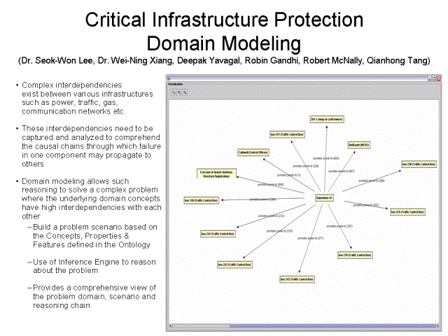
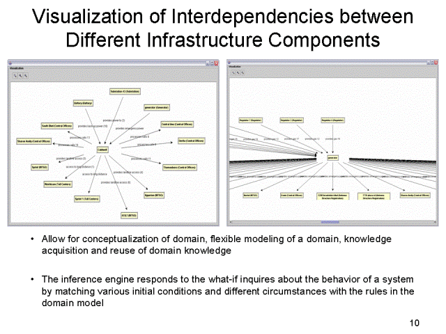
In this project, we study an object-oriented method that facilitates CIP professionals’ learning of the interactions among CI components in relation to the functionality of a public utility system. Employing an integrated system of GIS and a generic object modeling tool (GenOM), it represents and visualizes the two pieces of knowledge both geographically and diagrammatically. Both the interactions among different CI components and their effects on the functionality of a utility system can be vividly rendered. Furthermore, the inference engine embedded in GenOM allows CIP professionals to explore various scenarios of utility system failure and their spatial ramifications with “what-if” queries.


Selected Documents/Publications:

McNally, R., Lee, S.W. and Xiang, W-N. Abstract: “An Ontology-based Approach for Representing and Visualizing Interdependencies across Critical Infrastructures” In Proceedings of the 9th International Computers in Urban Planning and Urban Management Conference (CUPUM ’05), June 29 – July 1. University College London.

McNally, R., Lee, S.W., Yavagal, D.S. and Xiang, W-N. “An Ontology-driven Approach to Representing and Visualizing Critical Infrastructure Interdependencies”, In Proceedings of the Auto-Carto 05, A CaGIS Research Symposium, March 18-23, Las Vegas. The Cartography and Geographic Information Society (CaGIS).  2005. 

McNally, R., Lee, S.W., Yavagal, D.S. and Xiang, W-N. Abstract: “An Object-Oriented Method For Representing And Visualizing Interdependencies Across Critical Infrastructure Layers”, Abstract: The 2005 Meeting of The Association of American Geographers (AAG ‘05), 101st AAG Annual Meeting, April 5-9, Denver, Colorado. 2005.

© 2005 NiSE Research Group
Page Maintained By: The NiSE Research Group